

Exploring the Geography of Gilgit Baltistan
(Gilgit Baltistan Map) Nestled in the northernmost region of Pakistan, Gilgit Baltistan is a land of stunning landscapes, rich cultural heritage, and geographical significance. Known for its breathtaking mountains, serene valleys, and vibrant communities, this region is a paradise for nature lovers and adventurers alike. In this article, we will explore the geography of Gilgit Baltistan, (Gilgit Baltistan Map) its key geographical features, and its importance on the map of Pakistan.
Summary
(Gilgit Baltistan Map) This article explores Gilgit Baltistan’s strategic northern location and extraordinary high-mountain geography Karakoram peaks like K2, extensive glaciers, major rivers, valleys, and lakes—showing why its map is vital. It highlights geopolitical importance via CPEC and the Khunjerab Pass, alongside tourism and resource mapping. The region’s varied climate underpins rich biodiversity, while cultural diversity, historical sites, and festivals showcase a vibrant heritage. Key challenges include climate change and infrastructure needs, with opportunities in eco-tourism, sustainable agriculture, and renewable energy.
An Introduction to Gilgit Baltistan
Gilgit Baltistan, often abbreviated as GB, is one of the most scenic and culturally rich regions of Pakistan. It shares borders with Afghanistan to the northwest, China to the north, and India to the east. This strategic location has made Gilgit Baltistan a significant point of interest not only for its natural beauty but also for geopolitical reasons.
Key Features of Gilgit Baltistan (Gilgit Baltistan Map)
The region is known for several key geographical features that make it unique:
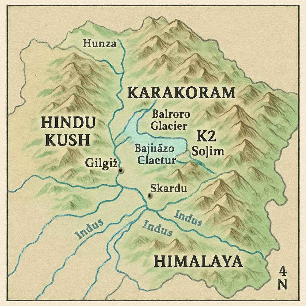
- Mountain Ranges: Gilgit Baltistan is home to some of the world’s highest peaks, including K2, the second-highest mountain on earth. The Karakoram Range, which runs through the region, is a sight to behold for mountaineers and hikers.
- Glaciers and Rivers: The area is dotted with glaciers, including the Baltoro Glacier, one of the largest outside the polar regions. The Indus River, one of the longest rivers in Asia, also flows through this region, providing essential water resources for agriculture and hydroelectric power.
- Valleys and Lakes: Gilgit Baltistan boasts a variety of valleys such as Hunza, Skardu, and Gilgit, each offering unique landscapes and cultural experiences. The region’s lakes, such as Sheosar Lake and Satpara Lake, add to its scenic beauty.
Importance of the Gilgit Baltistan Map
The map of Gilgit Baltistan is crucial for understanding its geographical layout and significance. It highlights the region’s diverse topography, strategic location, and natural resources.
Geopolitical Significance
Gilgit Baltistan’s location makes it a key area for geopolitical interests. It serves as a gateway to the China-Pakistan Economic Corridor (CPEC), which is part of China’s Belt and Road Initiative. The region’s connectivity with China through the Khunjerab Pass, the highest paved international border crossing, underscores its importance on the geopolitical map. (Gilgit Baltistan Map)
Tourism and Natural Resources

The map of Gilgit Baltistan is also essential for tourism, as it guides travelers to its many attractions. The region’s natural resources, including minerals and forests, are vital for local economies. Mapping these resources helps in their sustainable management and utilization.
Climate and Biodiversity
Gilgit Baltistan’s geography significantly influences its climate and biodiversity. The region experiences a range of climates due to its varied altitudes.
Climate Zones
- Highland Climate: In the higher altitudes, the climate is cold and dry, with heavy snowfall during the winter months. Summers are short and mild, making it an ideal time for trekking and mountaineering.
- Valley Climate: The valleys have a moderate climate, with warmer summers and cold winters. This makes the valleys suitable for agriculture, particularly for growing fruits like apricots and cherries.
Flora and Fauna
The diverse climate zones support a wide range of flora and fauna. The region is home to unique species such as the snow leopard, Himalayan ibex, and the markhor, Pakistan’s national animal. Conservation efforts are crucial for protecting these species and their habitats.
Cultural Diversity and Heritage
Gilgit Baltistan is not only known for its natural beauty but also for its rich cultural heritage. The region is home to various ethnic groups, each with its own language, traditions, and customs.
Ethnic Groups and Languages
The major ethnic groups include the Shina, Balti, Burusho, and Wakhi people, among others. Each group has its own language, adding to the region’s linguistic diversity. The preservation of these languages and cultures is an essential part of the region’s identity.
Historical Sites and Festivals
Gilgit Baltistan is dotted with historical sites that reflect its rich past. Ancient rock carvings, forts, and Buddhist relics provide a glimpse into the region’s history. Festivals such as the Jashn-e-Baharan and the Polo Festival are celebrated with great enthusiasm, showcasing the region’s vibrant culture.
Challenges and Opportunities
While Gilgit Baltistan is a region of immense beauty and potential, it also faces several challenges.
Environmental Concerns
Climate change poses a significant threat to the region’s glaciers and water resources. The melting glaciers can lead to glacial lake outburst floods (GLOFs), which can have devastating effects on local communities. Sustainable environmental practices are crucial to mitigate these risks.
Infrastructure and Development
Infrastructure development is essential for the region’s growth and connectivity. Improved roads, healthcare, and education facilities can enhance the quality of life for the people of Gilgit Baltistan and promote tourism.
Economic Opportunities
The region’s natural beauty and resources present numerous economic opportunities. Promoting eco-tourism, sustainable agriculture, and renewable energy can boost the local economy while preserving the region’s natural heritage.
Conclusion (Gilgit Baltistan Map)
Gilgit Baltistan is a region of unparalleled beauty and diversity, both in its geography and culture. Its strategic location, rich natural resources, and cultural heritage make it a vital part of Pakistan. By understanding the geography of Gilgit Baltistan and addressing its challenges, we can ensure that this remarkable region continues to thrive and captivate visitors from around the world. As we explore the map of Gilgit Baltistan, we discover not just a place, but a living tapestry of nature and humanity intertwined.
Q&A
Question: Where is Gilgit Baltistan located, and why is its map strategically important? Short answer: (Gilgit Baltistan Map) Gilgit Baltistan sits at Pakistan’s northernmost edge, bordering Afghanistan (northwest), China (north), and India (east). Its map highlights this gateway position, especially the Khunjerab Pass—the highest paved international border crossing—linking Pakistan to China and the China-Pakistan Economic Corridor (CPEC). Mapping the region clarifies its rugged topography and routes that underpin trade, connectivity, and geopolitics.
Question: What geographic features make Gilgit Baltistan unique? Short answer: The region is dominated by the Karakoram Range and iconic peaks like K2, the world’s second-highest mountain. It hosts vast glaciers such as Baltoro (one of the largest outside the poles), the Indus River that powers agriculture and hydropower, and scenic valleys—Hunza, Skardu, and Gilgit—along with lakes like Sheosar and Satpara. Together, these features create a landscape renowned for mountaineering, trekking, and natural beauty.
Question: How does the climate vary across Gilgit Baltistan, and what does that mean for biodiversity and agriculture? Short answer: Climate shifts with altitude: highlands are cold, dry, and snowy in winter with short, mild summers, while valleys are comparatively moderate—warmer summers and cold winters. These zones support rich biodiversity, including snow leopards, Himalayan ibex, and the markhor, and enable valley agriculture, especially fruit like apricots and cherries. Conservation is vital to protect habitats across this climatic gradient.
Question: How do culture and heritage stand out in Gilgit Baltistan? Short answer: GB is culturally diverse, home to Shina, Balti, Burusho, Wakhi, and other communities, each with distinct languages and traditions. Its landscape features historical sites—ancient rock carvings, forts, and Buddhist relics—that reflect a deep past. Festivals such as Jashn-e-Baharan and the Polo Festival showcase living traditions and communal celebration. (Gilgit Baltistan Map)
Question: What challenges does Gilgit Baltistan face, and where are the opportunities? Short answer: Climate change threatens glaciers and raises risks of glacial lake outburst floods (GLOFs), while infrastructure gaps in roads, healthcare, and education constrain growth. Opportunities lie in eco-tourism, sustainable agriculture, and renewable energy, with careful resource mapping (minerals, forests) enabling responsible development that preserves the region’s natural and cultural heritage. (Gilgit Baltistan Map)


