(Gilgit Baltistan Districts Map) Gilgit Baltistan is a region that captivates the imagination with its stunning landscapes, rich cultural heritage, and historical significance. Nestled in the northern areas of Pakistan, this region is home to some of the world’s highest peaks and most breathtaking valleys. In this article, we will embark on an exploration of the districts of Gilgit Baltistan, providing you with a comprehensive guide to understanding this beautiful region.

Gilgit Baltistan, often abbreviated as GB, is one of the most picturesque regions in Pakistan. It is located in the northern part of the country and shares borders with China, Afghanistan, and the Indian-administered union territories of Jammu and Kashmir and Ladakh. The region is known for its diverse ethnic groups, languages, and cultures, making it a unique blend of traditions and modernity.
Geographical Significance (Gilgit Baltistan Districts Map)
The geographical location of Gilgit Baltistan places it at a strategic crossroads in South Asia. Flanked by towering mountain ranges, such as the Himalayas, the Karakoram, and the Hindu Kush, the region serves as a natural barrier and a melting pot of cultures. These mountains are not just barriers but also guardians of biodiversity, with countless endemic species thriving in their altitudinal gradients.
Cultural Diversity
Gilgit Baltistan is a mosaic of various ethnic groups, each with its distinct language, customs, and traditions. The region is home to the Balti, Shina, Burusho, Wakhi, and several other communities, each contributing to the cultural richness of the area. Festivals, traditional music, and dance are integral parts of life here, offering visitors a glimpse into the vibrant cultural tapestry that defines Gilgit-Baltistan.
Economic Potential
The economy of Gilgit Baltistan is primarily based on agriculture, tourism, and trade. The region’s fertile valleys yield an abundance of fruits, nuts, and cereals, while its rugged terrains and scenic beauty attract tourists from around the globe. Additionally, the strategic location of Gilgit-Baltistan makes it a critical transit route for trade between China and Pakistan, further boosting its economic significance.
The Importance of Maps in Gilgit Baltistan
Maps play a crucial role in navigating the rugged terrains and exploring the districts of Gilgit Baltistan. A detailed Gilgit Baltistan map can be your best companion in understanding the geographical layout of the region. Whether you’re a traveler, a researcher, or simply a curious explorer, having access to a map of GB is essential for planning your journey and discovering the hidden gems of this area.
Navigational Aid
In a region where terrain can be both breathtaking and challenging, maps serve as an indispensable navigational aid. From guiding trekkers through mountain passes to assisting researchers in identifying geological features, maps provide a comprehensive overview of the landscape. For travelers, maps are not just tools for navigation but also gateways to adventure, unlocking paths less traveled.
Historical Context Gilgit Baltistan Districts Map
Maps of Gilgit Baltistan not only chart the current geography but also reveal historical routes and settlements. Ancient trade routes, such as the Silk Road, have traversed these lands, leaving behind a rich legacy of cultural exchange and commerce. Historical maps can help enthusiasts trace these routes and better understand the historical significance of the region’s geography.
Planning and Safety
For adventurers and tourists, maps are crucial for planning itineraries and ensuring safety. The rugged and sometimes unforgiving terrain of Gilgit Baltistan requires careful planning and consideration of weather conditions. Maps help travelers identify safe routes, locate emergency services, and find accommodations, ensuring a safe and enjoyable journey through this captivating region.
Gilgit District
Introduction to Gilgit Baltistan Districts Map

Gilgit is the administrative center of Gilgit Baltistan and serves as a gateway to the rest of the region. This district is known for its strategic location and historical significance. Gilgit town itself is a bustling hub with a mix of traditional bazaars and modern amenities.
Historical Significance (Gilgit Baltistan Districts Map)
The history of Gilgit is as rich as its landscapes. As a crucial point along the ancient Silk Road, Gilgit has been a significant center for trade and cultural exchange for centuries. The district’s historical architecture, such as the remnants of forts and Buddhist artifacts, provides a window into its storied past and its role in regional trade networks.
Cultural Vibrancy
Gilgit is a cultural melting pot, where various ethnic communities coexist and celebrate their unique traditions. Traditional festivals, such as the Shandur Polo Festival, bring together people from different backgrounds, showcasing the region’s cultural diversity. The local markets are vibrant with traditional handicrafts, music, and culinary delights, offering visitors an immersive cultural experience.
Economic Hub
As the administrative center, Gilgit acts as the economic heartbeat of the region. It hosts numerous businesses and markets, facilitating trade and commerce throughout Gilgit Baltistan. The district’s economy thrives on agriculture, tourism, and trade, with local bazaars bustling with activity, offering everything from local produce to artisanal crafts. (Gilgit Baltistan Districts Map)
Key Attractions in Gilgit Baltistan Districts Map
Kargah Buddha
The Kargah Buddha is an ancient rock carving that dates back to the 7th century, located about 10 km from Gilgit town. This historical site provides insight into the Buddhist heritage of the region, reflecting the cultural exchanges that took place along the Silk Road. The serene setting and historical significance make it a must-visit for history enthusiasts and tourists alike.
Naltar Valley
Naltar Valley is renowned for its vibrant-colored lakes and lush forests. It transforms into a winter wonderland with its ski resort attracting adventure seekers and nature lovers. The valley’s pristine beauty and tranquil environment offer a perfect escape from the hustle and bustle of city life, making it a popular destination for tourists and photographers.
Gilgit Bridge
The Gilgit Bridge, a suspension bridge over the Gilgit River, is a marvel of engineering and a significant landmark. Offering panoramic views of the river and surrounding mountains, the bridge is a popular spot for photography and sightseeing. Its strategic location connects various parts of the district, facilitating trade and travel. (Gilgit Baltistan Districts Map)
Baltistan Districts

Skardu District
Skardu is the heart of Baltistan and is often referred to as the “Land of Giants” due to its towering peaks. This district is a paradise for mountaineers and trekkers, with stunning landscapes that include the famous Deosai Plains.(Gilgit Baltistan Districts Map)
Gateway to Adventure
Skardu serves as the gateway to some of the most challenging and rewarding treks in the world. The district is a starting point for expeditions to peaks like K2, Broad Peak, and the Gasherbrums. The thrill of adventure, coupled with the breathtaking beauty of the landscapes, draws mountaineers and trekkers from around the globe.
Cultural Heritage
The district’s cultural heritage is as rich as its natural beauty. The Balti people, with their unique traditions and language, add to the cultural tapestry of the region. Visitors can experience traditional Balti hospitality, music, and cuisine, gaining a deeper appreciation for the local way of life.
Deosai Plains (Gilgit Baltistan Districts Map)
The Deosai Plains, known as the “Land of the Giants,” are a vast expanse of high-altitude meadows that come alive with wildflowers during the summer. This national park is home to a diverse range of wildlife, including the Himalayan brown bear and snow leopard. The serene beauty and tranquility of Deosai make it a popular destination for nature lovers and wildlife enthusiasts.(Gilgit Baltistan Districts Map)
Key Attractions in Skardu (Gilgit Baltistan Districts Map)
Shangrila Resort
Shangrila Resort, often dubbed “Heaven on Earth,” is a picturesque retreat located by a serene lake. The resort offers luxurious accommodations and stunning views, providing a perfect blend of nature and comfort. Its idyllic setting and warm hospitality make it a favorite among tourists seeking relaxation and rejuvenation.(Gilgit Baltistan Districts Map)
Deosai National Park
Deosai National Park is a haven for wildlife and a paradise for nature enthusiasts. The park’s vast meadows and diverse ecosystems support a wide variety of flora and fauna. Visitors can explore the park’s trails, observe wildlife, and soak in the breathtaking views, making it an unforgettable experience.
K2 Base Camp
The trek to K2 Base Camp is a challenging yet rewarding journey that attracts adventurers from all over the world. The trail passes through some of the most stunning landscapes, offering views of towering peaks and pristine glaciers. Reaching the base camp of the world’s second-highest mountain is a testament to human endurance and the allure of nature’s grandeur.
Ghanche District
Ghanche is renowned for its unique cultural heritage and beautiful valleys. The district is home to the historic Khaplu Palace and offers breathtaking views of the Karakoram Range.
Architectural Marvels
Ghanche is a treasure trove of architectural wonders, with Khaplu Palace being a prime example. This historic palace, now a hotel, showcases traditional Balti architecture and craftsmanship. Visitors can explore its intricately designed rooms and gardens, gaining insight into the region’s architectural heritage.
Cultural Experiences
The district offers rich cultural experiences, with traditional festivals and events celebrating the local heritage. Visitors can witness traditional dances, music, and rituals, gaining a deeper understanding of the Balti culture. Engaging with the local community provides a unique opportunity to appreciate the region’s cultural richness.
Scenic Valleys (Gilgit Baltistan Districts Map)
Ghanche’s valleys are renowned for their breathtaking beauty and tranquility. The Hushe Valley, a gateway to numerous trekking routes, offers stunning views of the Karakoram Range. The region’s natural beauty and serene environment make it a perfect destination for those seeking peace and solitude.(Gilgit Baltistan Districts Map)
Key Attractions in Ghanche
Khaplu Palace
Khaplu Palace is a stunning architectural marvel that now operates as a hotel. Its intricate design and historical significance make it a must-visit for history enthusiasts and architecture lovers. The palace offers a glimpse into the region’s royal past and provides a luxurious stay for visitors.
Hushe Valley
Hushe Valley is a starting point for treks to the famous Masherbrum and K6 peaks. The valley’s stunning landscapes and challenging trails attract trekkers and mountaineers from around the world. Its remote location and pristine beauty offer a true escape into nature.
Siachen Glacier (Gilgit Baltistan Districts Map)
Siachen Glacier, the highest battlefield in the world, is located in the eastern Karakoram Range. The glacier’s strategic significance and challenging environment make it a fascinating destination for adventurers and history enthusiasts. Exploring the glacier provides insight into the region’s geopolitical importance and natural beauty.(Gilgit Baltistan Districts Map)
Diamer District
Diamer is a district that holds immense historical significance. It is home to the famous Babusar Pass and serves as a gateway to the Fairy Meadows, offering breathtaking views of Nanga Parbat, the “Killer Mountain.”
Historical Significance
Diamer’s history is intertwined with the ancient trade routes that passed through the region. The district’s historical sites and artifacts provide insight into its past and the cultural exchanges that took place over the centuries. Exploring Diamer’s history offers a deeper understanding of the region’s role in shaping the cultural landscape of (Gilgit Baltistan Districts Map).
Gateway to Adventure(Gilgit Baltistan Districts Map)
Diamer is a gateway to some of the most stunning natural landscapes in the region. The district’s location makes it a perfect starting point for adventures to Fairy Meadows and Nanga Parbat. The thrill of exploration and the allure of the mountains make Diamer a popular destination for adventurers.
Natural Beauty

The district’s natural beauty is unparalleled, with lush valleys, towering peaks, and pristine lakes. Diamer’s landscapes offer a perfect blend of adventure and tranquility, attracting nature lovers and photographers. The district’s scenic beauty and serene environment provide a perfect escape from the hustle and bustle of city life. (Gilgit Baltistan Districts Map)
Key Attractions in Diamer (Gilgit Baltistan Districts Map)
Fairy Meadows
Fairy Meadows is a lush green plateau that provides stunning views of Nanga Parbat. The meadows’ serene beauty and breathtaking vistas make it a popular destination for trekkers and nature lovers. Camping at Fairy Meadows offers a unique opportunity to experience the region’s natural beauty and tranquility.
Babusar Pass
Babusar Pass is a high-altitude pass connecting GilgitnBaltistan with Khyber Pakhtunkhwa. The pass offers panoramic views of the surrounding mountains and valleys, making it a popular spot for photography and sightseeing. Its strategic location and stunning landscapes make it a must-visit for travelers. (Gilgit Baltistan Districts Map)
Rama Lake
Rama Lake is a picturesque lake surrounded by lush greenery. The lake’s tranquil environment and stunning views make it a popular destination for tourists and nature lovers. Visitors can enjoy a peaceful retreat, exploring the lake’s surroundings and soaking in its natural beauty.
Ghizer District (Gilgit Baltistan Districts Map)
Ghizer is known for its serene landscapes and diverse cultural heritage. It is a district where you can experience the true essence of Gilgit-Baltistan’s natural beauty.
Cultural Heritage
Ghizer is a melting pot of cultures, with various ethnic groups coexisting and celebrating their unique traditions. The district’s cultural festivals and events showcase the rich heritage of the region, offering visitors a glimpse into the local way of life. Engaging with the local community provides a deeper understanding of the district’s cultural richness.
Scenic Beauty
The district’s scenic beauty is unparalleled, with lush valleys, turquoise lakes, and towering mountains. Ghizer’s landscapes offer a perfect blend of adventure and tranquility, attracting nature lovers and photographers. The district’s natural beauty and serene environment provide a perfect escape from the hustle and bustle of city life.
Adventure and Exploration
Ghizer offers numerous opportunities for adventure and exploration, with trekking routes and trails leading to stunning vistas and hidden gems. The district’s diverse landscapes and challenging terrain attract adventurers and explorers from around the world. Whether it’s trekking, hiking, or simply exploring the region’s natural beauty, Ghizer offers an unforgettable experience.
Key Attractions in Ghizer

Phander Valley
Phander Valley, often referred to as “Little Kashmir” is famous for its turquoise waters and lush landscapes. The valley’s pristine beauty and tranquil environment make it a popular destination for tourists and nature lovers. Visitors can explore the valley’s surroundings, enjoying the stunning views and serene atmosphere.
Yasin Valley
Yasin Valley is known for its rich history and stunning scenery. The valley’s lush landscapes and historical sites attract visitors seeking adventure and exploration. The district’s natural beauty and cultural heritage make it a perfect destination for those seeking a deeper understanding of the region’s history and culture.
Shandur Pass
Shandur Pass is famous for hosting the annual Shandur Polo Festival, attracting visitors from all over the world. The pass’s stunning landscapes and vibrant cultural events make it a popular destination for tourists and adventure seekers. The festival offers a unique opportunity to experience the region’s cultural heritage and enjoy the thrill of polo.
Hunza District (Gilgit Baltistan Districts Map)
Hunza is perhaps the most famous district in Gilgit Baltistan, known for its majestic mountains and vibrant culture. The people of Hunza are known for their hospitality and longevity.
Cultural Richness
Hunza’s cultural richness is reflected in its vibrant traditions, music, and festivals. The district’s cultural events and celebrations offer visitors a glimpse into the local way of life and the region’s rich heritage. Engaging with the local community provides a deeper understanding of Hunza’s cultural richness and traditions.
Natural Beauty
The district’s natural beauty is unparalleled, with majestic mountains, serene valleys, and pristine lakes. Hunza’s landscapes offer a perfect blend of adventure and tranquility, attracting nature lovers and photographers. The district’s scenic beauty and serene environment provide a perfect escape from the hustle and bustle of city life.
Adventure and Exploration
Hunza offers numerous opportunities for adventure and exploration, with trekking routes and trails leading to stunning vistas and hidden gems. The district’s diverse landscapes and challenging terrain attract adventurers and explorers from around the world. Whether it’s trekking, hiking, or simply exploring the region’s natural beauty, Hunza offers an unforgettable experience.
Key Attractions in Hunza
Baltit Fort
Baltit Fort is a 700-year-old fort that offers panoramic views of the Hunza Valley. The fort’s historical significance and stunning architecture make it a must-visit for history enthusiasts and architecture lovers. Visitors can explore the fort’s rooms and halls, gaining insight into the region’s royal past and cultural heritage.
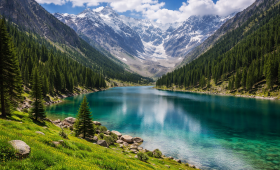
Attabad Lake
Attabad Lake is a lake formed as a result of a landslide, known for its striking blue waters. The lake’s serene beauty and stunning views make it a popular destination for tourists and nature lovers. Visitors can enjoy a peaceful retreat, exploring the lake’s surroundings and soaking in its natural beauty.
Passu Cones
Passu Cones are iconic sharp peaked mountains that are a photographer’s delight. The cones’ stunning beauty and dramatic landscapes make them a popular destination for tourists and adventure seekers. Visitors can explore the region’s trails and paths, enjoying the breathtaking views and serene atmosphere.
Conclusion
Exploring the districts of Gilgit Baltistan is an adventure like no other. From the bustling town of Gilgit to the serene valleys of Hunza and the challenging treks of Skardu, this region offers something for every traveler. With a Gilgit Baltistan districts map in hand, you can navigate through this enchanting land and create memories that will last a lifetime. Whether you’re an avid trekker, a history enthusiast, or simply someone seeking tranquility in nature, Gilgit Baltistan is a destination that promises to leave you in awe.
In conclusion, the diverse districts of Gilgit Baltistan are a testament to nature’s grandeur and the rich cultural tapestry of Pakistan. So, pack your bags, grab your map, and embark on a journey to discover the hidden treasures of this mesmerizing region. (Gilgit Baltistan Districts Map)